Showing posts with label Auldearn Battlefield. Show all posts

Monday, March 2, 2015

Auldearn - Coming to WSS May Edition

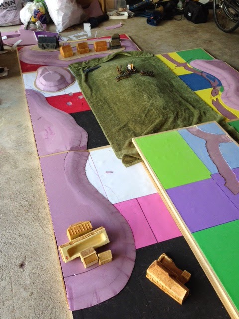
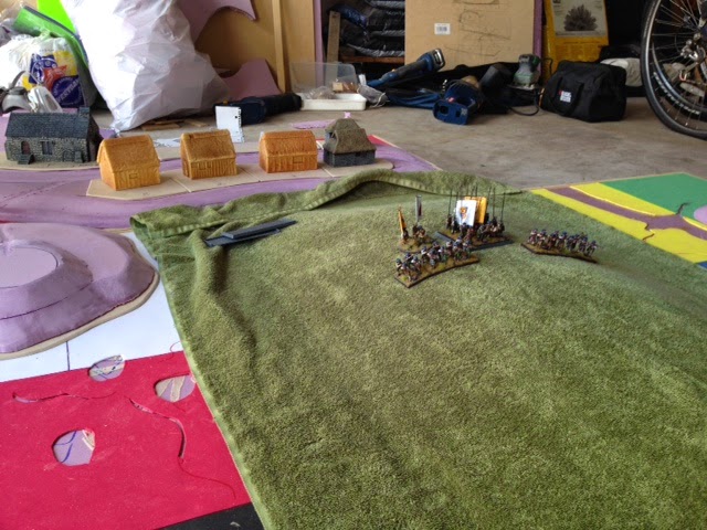
Yesterday we took the photos to accompany our article on Auldearn.

It was the first time we had the table out, buildings and trees on, and all the figures out.

Really, it was the end of 7 years hard work.

The photos below are a taster - taken on the phone, with the main ones on the camera going to the magazine.

We never played it as a game - more just moved the troops to record what happened .

I think we nailed the scales on the terrain, which proved to be confining for the convenanters as they were sucked in towards the village.

We get to play it in two weeks - getting a rest from glue and paint just now.


Terrain V - Auldearn Village

Auldearn village and Kirk.  Buildings are light-weight extruded foam models originally produced by Hudson and Allen (now sold by Vatican Enterprises), mounted on thin sheets of MDF (1/8" thick) with Rendra plastic wattle fences. 


Auldearn Kirk is a (heavy) resin model originally manufactured by PMC Terrain/Games and called "Medieval Church". I picked this up on Ebay back in 2007 from seller "sellthatstuffboy" who was then acting as a manufaturer/re-seller for the PMC range.The kirk yard is decorated with plastic Renedra gravestones.

Saturday, February 28, 2015

Terrain IV

Spent the last couple of meetings dry-brushing the terrain and making it come to life.  The grass took a couple of "lightening-up's" to really come out - the roads, having a bit more obvious texture, jumped out straight away.

Again, the light is problematic as can be seen in the shots below - all taken within about 3 minutes of each other.

We thought hard about how to represent the marshy areas which played such an important part in the battle, eventually just doing some washes and bespoke dry-brushing. - think it came out better than it may appear in the shots.


Detail around Castle Hill showing the texture that the toweling brings.


Based up some trees - mix of Woodland Scenic types and old GW.  CD's and steel washers provide the bases, allowing a little more stability.  All the exposed bark was painted - got away from the plastic sheen.

Had hoped to buy some rubberized horsehair ones but couldn't find a good supplier here in the states.


Monday, February 23, 2015

Terrain Building III

Spent most of yesterday painting the towels to get a consistent finish - the dying having been a bit hit and miss.  All the fabric types blend pretty well - next stage is the dry brushing

Getting the roads on was also done - nice contrast with the green.

Amazing how the colors change depending on the light/angle...


Monday, February 16, 2015

Terrain Building II

Started the business of "dressing the boards this weekend.Rather than grass-mat or painted sand, we chose to use toweling dyed olive green (mostly), using Dylon dyes.  As no two batches are exactly the same (different dilutions, amounts of salt used to fix colours) we ended up with a variety of tones.


These shots look down the board to Auldearn village, showing Garlic Hill in the centre and Castle Hill off to the flank. Still got some gaps to fill in and the roads to paint and texture.


The towel was stuck down with a mix of wood-glue and plaster of paris, but we need to fix some of the edges, then saturate the whole thing with watered down pva for extra strength.  This should also give us a better texture to dry brush the towel, breaking down the hard edges.


Castle Hill is the only lay down terrain on the board all the other hills are intrinsic - helps stop warping.


Good view "up-table" showing the layout of the village


Some Covenanters and Macollas Lifeguard fro scale


Detailed shot giving a feel for the texture on Garlic Hill.


With most pike and shotte regiments having a foot of frontage - even big features such as this will get cluttered fairly quickly.


View from the defenders side.


Wednesday, February 11, 2015

Terrain Building I

The last couple of weeks have been spent building the boards for the battlefield.  We have a hard deadline on this part of the project for if we want to get it into the next WSS article (due out in May) - we need the photographs out by the end of February.

We decided that we'd build enough boards to cover 6' by 24' - as this would give us plenty of variety going forward - with the Auldearn Board (6'by 8') being the main aim. This meant we had a lot of work to do.

The basic design would utilise 2' by 4' mdfs, and we buildt beading around the edges, fitting 1/2inch foam insulation into the center - so we got strength with lightness.

The terrain was then outlines and height build up by adding more sheets of foam


Auldearn Village - basic design


Auldearn Village - hill sculpt - note additional thin sheets of foam added to level up 1/2 inch insulation foam.


Garlic Hill - center point of the battle - 2" of hill built up


It was essential the slopes were gentle enough that the figures were standing reasonably vertically - so we couldn't build up to much height.


We have through hard about cladding the boards and think a variety of dyed toweling and some limited grass mat will give a good effect - this is pretty similar to the stuff on the Perry's site - which has been a great inspiration.


Boards looking pretty big - this shows relationship of Garlic Hill, Castle Hill and Auldearn Village


Detail of "clad" Garlic Hill with Monymore's Regiment guarding the crest.

The houses have all been painted, each will have its own small tile with fencing etc.

We only have a little sanding on some other hills and painting of the board edges before we get down to the dressing phase - hopefully it should be done this weekend......


Wednesday, March 26, 2014

Maps - moving towards a battlefield landscape

Getting the terrain right for Auldearn might be trickier than first seems.  Although the battlefield is on gently rolling countryside, what you can see on foot is a lot different from what you expect to see from a map or satellite image.  Two to five metres elevation hides a lot of things so a lot can happen between a couple of contour lines.  That being said, this map from Historic Scotland's battlefield archaeology team is a good start.

Ordanance survey maps are still some of the best maps in the world getting the right amount of detail with excellent clarity. In addition, Historic Scotland did some soil analysis and identified areas of alluvium - pinpointing areas of marsh which have since been drained. 


The oldest map of the area I could find was General Roy's from 1746-7, one hundred years after the battle. In the century since Auldearn, new farming techniques had begun to reclaim land by defining surface drainage through better control of the natural stream systems. However, on Roy's map, areas of marshy ground can still be seen.


If we look at the image on GoogleEarth the areas of poor drainage, tied to the presence of mapped alluvium still show up


These played a significant part in the battle, funneling the Covenanters towards Auldearn, whilst constricting their deployment.  Although Garlic Hill is fairly high, enough topography exist around Aurldearn and the ridge running south that vision would be limited.  If you look at the video posted earlier on this blog, irrespective of modern housing and trees, you still blind to whats going on only a couple of hundred metres away.  So you can just imagine the Gordon Horse suddenly merging from cover and causing a surprise!


By simplifying the ordnance survey map, highlighting the contours and shading them, placing on streams and alluvium, the general shape of the old village, the battle field begins to take shape.  Garlic Hill points like a dagger into Auldearn, showing how Hurry could have over the course of a days fighting begun to suffer from "target-fixation"!


Sunday, June 26, 2011

Auldearn The Movie

360 from the summit of Garlic Hill.


Auldearn Battlefield

Auldearn has got to be one of the smallest battlefields I've ever been on.  This means that the butchers bill must have been pretty high where the action was (though a good lot of the covenanter casualties must have occurred during the rout.

Walking the terrain was good for although the hills are not that big the main three (Garlic, Castle and hill of the town) controlled not only what could be seen from any given point but also the nature of the drainage.

On either side of Garlic hill the ground is still marshy today (even with modern drainage).  This would have helped funnel the government troops along the axis of the hill, pushing MaColla and the Irish back towards the town.

However, the curve of the hill veers towards the present high street where most of the oldest houses of the village are situated. Here the land rises up again into both the town and towards the Castle hill.

From the summit of Garlic hill it is impossible to see anything other than the town and it's hills.  so the strength and position of the royalist army would have been hidden.  However, from the top of the Castle Hill, the royalist command would have been able to see most of the Covenanters and would have noticed how the regiments where stacked on top of each other, unable to bring their superior numbers to bear on the assault occurring in the village.


Garlic Hill from Castle Hill


The Doocoot on top of Castle Hill - this is a 18th century structure replacing the one which stood here during the battle


The view down the main road of Auldearn towards the front of the village - the fighting would have been down at the bottom end.


View towards Auldearn from the summit of Garlic Hill.  The Royalists would have been able to assemble their forces behind the village without the Hurry seeing how many where there and where they would be deployed. Main road into Auldearn is on the left.


Castle Hill with the doocoot on the summit.  The field below and to the other side of the road is still marshy.  The royalist cavalry swung round behind this emerging to the left to flank the government troops.